
Panama Canal Pilot System
Trimble is proud to be an approved provider of non-portable pilot systems for NeoPanamax vessels transiting the Panama Canal.
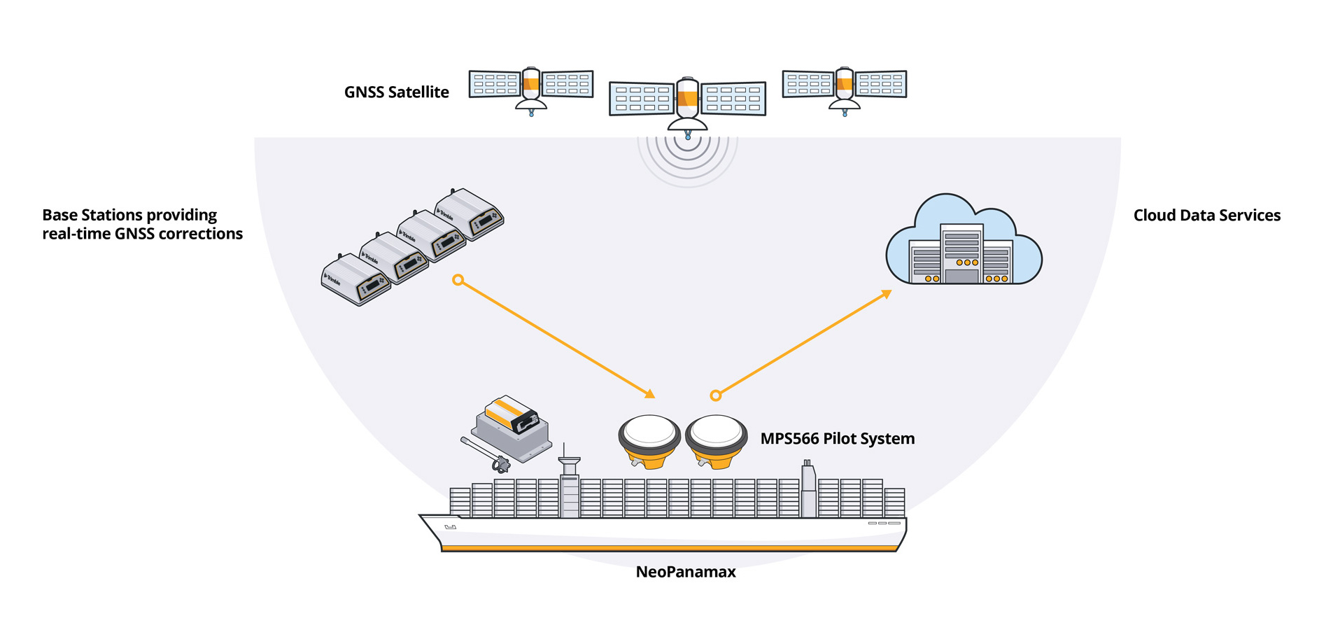
The Trimble MPS566 Pilot System
Approved by the Panama Canal Authority for permanent installation on NeoPanamax vessels transiting the canal. The system provides;
- Safe navigation - real-time centimeter level accuracy delivers high accuracy positioning and heading for precise guidance, berthing and docking
- Safe piloting - positioning data is shared with the Panama Canal pilot's application, delivering easy-to-read system status
- Independent AIS traffic monitoring - delivers data to Independent Automatic Identification System (AIS) traffic monitoring for the vessel
Vessel types
The MPS566 Pilot System is suitable for NeoPanamax vessel types including:
- Dry bulk vessels
- Container vessels
- Chemical tankers
- Liquefied Petroleum Gas (LPG) tankers
- Vehicle carriers
- Crude product tankers
- General cargo vessels
- Refrigerated vessels
- Liquefied Natural Gas (LNG) tankers
- Cruise ships
Canal de Panamá Advisory to shipping No. A-32-2022
Effective October 1, 2023, all vessels with a beam of 109 feet (33.22 meters) or more transiting the Panama Canal will be required to have a fixed (non-portable) piloting unit with Real Time Kinematics (RTK).
Review the Panama Canal approval and system information here.
Technical Information
Navigation
Trimble's patented GNSS receiver technology includes:
- Dual GNSS antenna inputs for precise heading
- Built in inertial measurement unit (IMU)
- OLED display with web user interface
GNSS Corrections
- The MPS566 receives GNSS corrections via Ultra High Frequency (UHF) or (optional) internet data from the Panama Canal precise GNSS base stations and servers.
- The system can operate autonomously for up to five hours without power from the vessel in case of a blackout.
Security
The MPS566 has spoofing and jamming detection, and a built-in backup battery that delivers five hours of power.
Communications
- 450 MHz UHF radio; Bluetooth® and Wi-Fi® communication; LTE(4G) cellular modem; SMS and email alerts
- Remote access to the receiver's web user interface (UI) or the AIS receiver web UI, for updates or support (when SIM card is installed)
- Single AIS/UHF antenna
Benefits of RTK Positioning
The GPS and GNSS satellite systems provide positional data that needs to be augmented in real-time to be precise. The MPS566 Pilot system uses real-time corrected data from ground based, permanently installed GNSS base stations that collect and correct GNSS data continuously.
When using the combination of data from satellites and GNSS ground based base stations, the real-time accuracy of the GNSS data becomes highly accurate.
The Panama Canal has installed many Trimble GNSS base stations, providing more precise data in real-time that is used for heading and piloting.
 DatasheetPDF Document - 250kb
 FAQPDF Document - 197kb
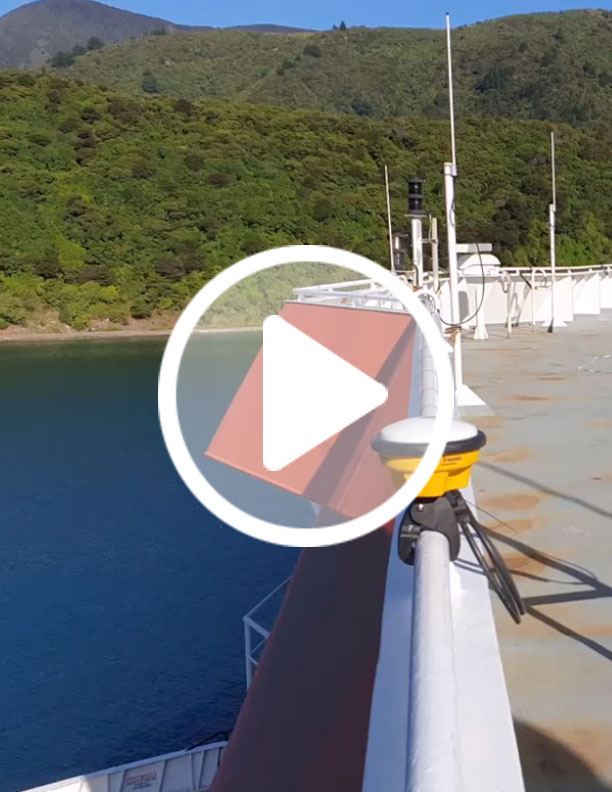 InstallationYouTube Video - 9m 47s
Frequently Asked Questions
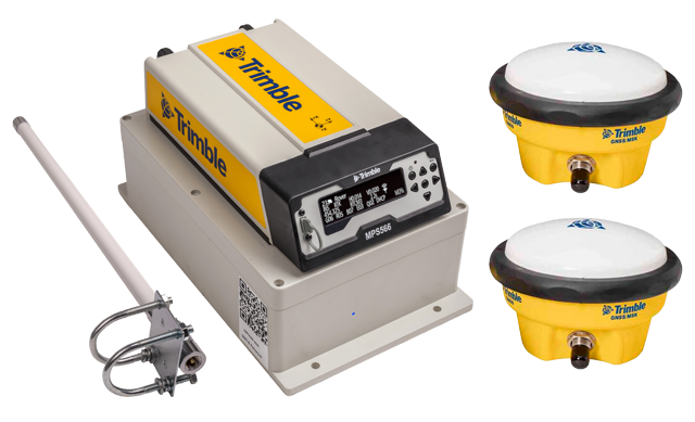
The Trimble MPS566 Pilot System
System details
The kit includes:
- A Trimble® MPS566 Modular GNSS Heading Receiver (with 450MHz UHF)
- RTK Rover with dual frequency GNSS and INS
- Two Trimble GA830 GNSS Antenna
- WTE Pilot Enclosure with AIS/UPS electronics
- WTE AIS/UHF antenna
- Optional WTE Antenna cabling kit with connectors and crimping tool. Alternatively the RG213 cables and connectors can be obtained from a local supplier
- Installation guide
Software is not included, but the common pilot applications, including the software used by the Panama Canal pilots will operate with the system.
The MPS566 Modular GNSS heading receiver transmits standard National Marine Electronics Association (NMEA) messages over Wi-Fi® - suitable for pilot systems. The Wi-Fi SSID and password is available on the QR Code label on the pilot plug panel.
The system is powered by connecting to 90-240 VAC in the wheelhouse. Common AC plugs are provided. In the event of AC power loss, the internal UPS powers the system for up to five hours.
No. However the Pilot's device might be connected to the Internet and NTRIP corrections can be streamed through to the MPS566 receiver as an alternative source of RTK corrections. The MPS566 receiver can support an LTE Sim card, if a direct Internet connection is required.
No. This is because the Panama Canal Authority (ACP) approval Certificate is related to a unique vessel.
Installation
The system hardware requires 180 mm W x 270 mm L and 160 mm H (7.1" W x 10.6" L x 6.3" H), in the wheelhouse.
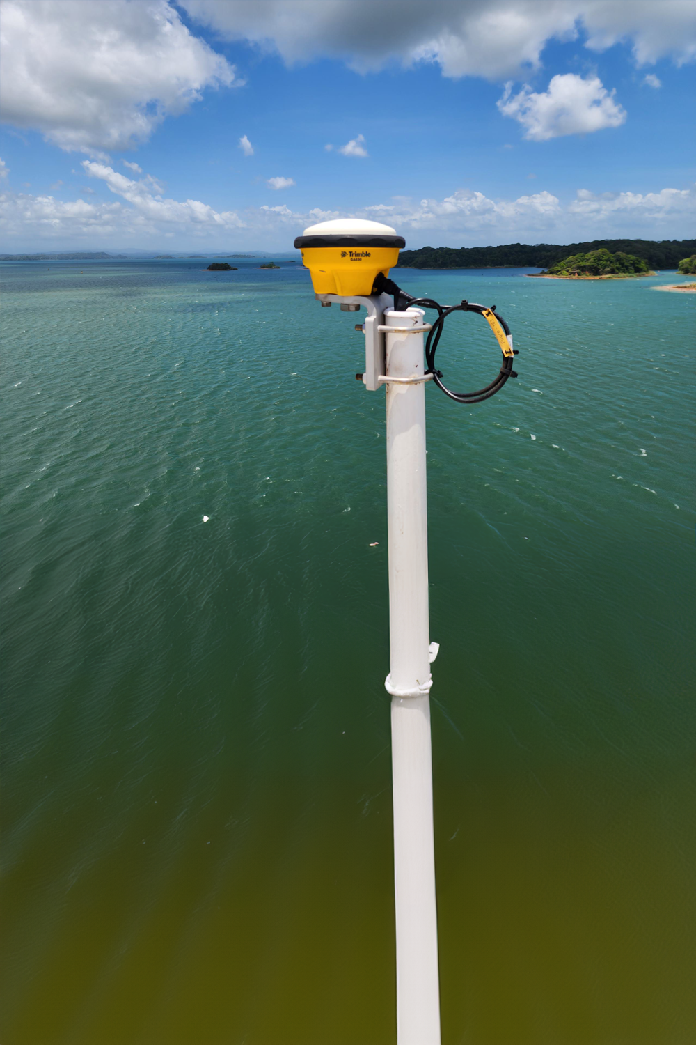
The GA830 GNSS antennas need to be installed on the compass deck clear of any radiated transmissions and ideally 10 meters (32.8 feet) apart, with a minimum separation of 4 meters (13 feet). Ideally antennas should be installed an equal distance to port and starboard from the vessels centreline, or directly alongship. The AIS/UHF antenna is mounted on the compass deck.
The installation process, which can be undertaken by a skilled crew, takes between 5 and 10 hours depending on the accessibility of mounting and cable-run locations. In most cases the vessel's crew can install antennas with the included antenna mounts (some fabrication may be required), run the cables from the compass deck to the back of the wheelhouse, and then enter measure up data to the MPS566 receiver.
The system is delivered pre-configured to operate with the Panama Canal infrastructure. The vessel's crew can enter the measure up offsets from the GNSS antennas to the GNSS receiver during installation to complete the configuration in preparation for the Panama Canal Authority certification. A YouTube instruction video is available for this process.
During the first transit through the Panama Canal the ACP Pilot team will confirm the offsets and create the Certificate for your vessel which is retained by the Panama Canal Authority to be re-used for subsequent transits.
The conventional AIS plug is not used for Panama Canal transits as the Pilot will use the Trimble MPS566 Pilot system.
General
Yes, the GNSS and AIS receive free GNSS corrections from various satellite-based augmentation system (SBAS) systems or free‑to‑air precise corrections in many seaports via UHF or NTRIP (via Internet). A Trimble RTX® Marine corrections subscription can be used to provide precise corrections globally.
There is Wifi and web UI password protection required.
No. However if you require L-band corrections such as Trimble RTX® correction service for non Panama Canal operation then this is a subscription service. If you install a LTE Sim card then the telecom supplier will charge for data.
Since these are Permanent Pilot Units they are installed on a given ship and can’t be rented.
Get in touch
Let's talk about your requirements!
To connect with Trimble, please fill out the form.


Trimble has a reputation for providing high-accuracy positioning, and has been a reliable and secure technology partner for shipping, farming, surveying, civil contractors and more for more than 35 years.
Innovation is at the core of our business. Since 1978, Trimble's technology solutions have been helping customers reach new levels of success by connecting information, positioning and communication.
Trimble solutions are at work in over 150 countries and we have employees in more than 40 countries. This, coupled with a highly capable network of global dealers, and distribution partners, helps our customers to thrive across the world, with local support.
© 2024 Trimble Inc | All Rights Reserved